Toggle navigation
Survey Subdivision Home
Viewers
Survey Subdivision GeoSearch
Survey Subdivision Text Search
Supporting data
Zip File Processing
Documentation
Survey Subdivision Tutorial
APIs
Survey Subdivision API
Search
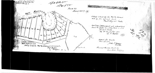
Plat: Souer's Point 4th Allotment
Download Original
Identity of Document
Id:
972
Subdivision name:
Souer's Point 4th Allotment
Document type:
Plat
Latitude:
40.9973261580755
Longitude:
-81.5318584442139
Dated on:
1910-07-05 19:00:00 -0500
Plat recorded in:
Book 12, pg. 24
Drawing Location:
Created at:
2009-06-30 13:49:20 -0400
Created by:
wschosta
 Download Original