Toggle navigation
Survey Subdivision Home
Viewers
Survey Subdivision GeoSearch
Survey Subdivision Text Search
Supporting data
Zip File Processing
Documentation
Survey Subdivision Tutorial
APIs
Survey Subdivision API
Search
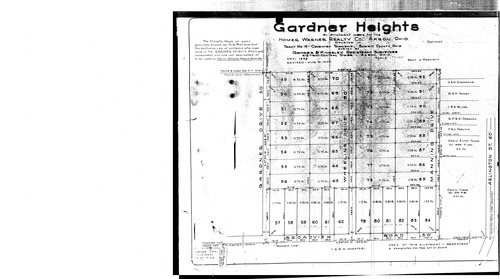
Plat: Gardener Heights
Download Original
Identity of Document
Id:
355
Subdivision name:
Gardener Heights
Document type:
Plat
Latitude:
40.9894873276972
Longitude:
-81.4979338645935
Dated on:
1939-08-30 20:00:00 -0400
Plat recorded in:
Book 37, pgs. 5 - 9
Drawing Location:
Created at:
2009-06-30 08:05:33 -0400
Created by:
zack
 Download Original