Toggle navigation
Survey Subdivision Home
Viewers
Survey Subdivision GeoSearch
Survey Subdivision Text Search
Supporting data
Zip File Processing
Documentation
Survey Subdivision Tutorial
APIs
Survey Subdivision API
Search
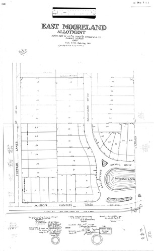
Plat: East Mooreland Allotment
Download Original
Identity of Document
Id:
239
Subdivision name:
East Mooreland Allotment
Document type:
Plat
Latitude:
40.9979415639737
Longitude:
-81.4076507091522
Dated on:
1920-06-14 20:00:00 -0400
Plat recorded in:
Book 28, pgs. 2 - 3
Drawing Location:
Created at:
2009-06-25 15:06:29 -0400
Created by:
zack
 Download Original