Toggle navigation
Survey Subdivision Home
Viewers
Survey Subdivision GeoSearch
Survey Subdivision Text Search
Supporting data
Zip File Processing
Documentation
Survey Subdivision Tutorial
APIs
Survey Subdivision API
Search
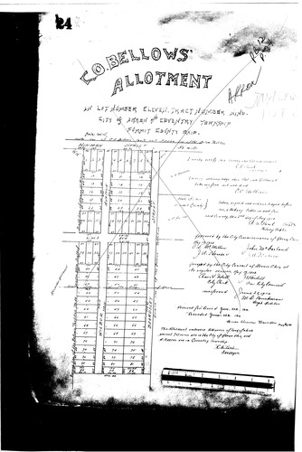
Plat: C.O. Bellows Allotment
Download Original
Identity of Document
Id:
145
Subdivision name:
C.O. Bellows Allotment
Document type:
Plat
Latitude:
41.0501815178349
Longitude:
-81.5138339996338
Dated on:
1910-06-27 19:00:00 -0500
Plat recorded in:
Book 12, pg. 24
Drawing Location:
Created at:
2009-06-25 13:38:08 -0400
Created by:
liz
 Download Original